Tornado Warnings for Cook, Will counties in Illinois, Lake County, Ind., have expired
Tornado warnings for Cook, Will, Iroquois and Kankakee counties in Illinois and Lake and Newton counties in Indiana have been canceled or expired.
A Ground Stop is in effect at O’Hare International Airport. A Ground Delay remains at Midway International Airport. Travelers should check with their airlines.
A Severe Thunderstorm Warning for Ford, Iroquois and Livingston counties is in effect until 6:30 p.m. and for Jasper, Lake, Newton and Porter counties in Indiana until 6:45 p.m.

A Dust Storm Advisory for Ford, Iroquois, Kankakee counties in Illinois and Benton, Jasper and Newton counties in Indiana is in effect until 6:45 p.m.
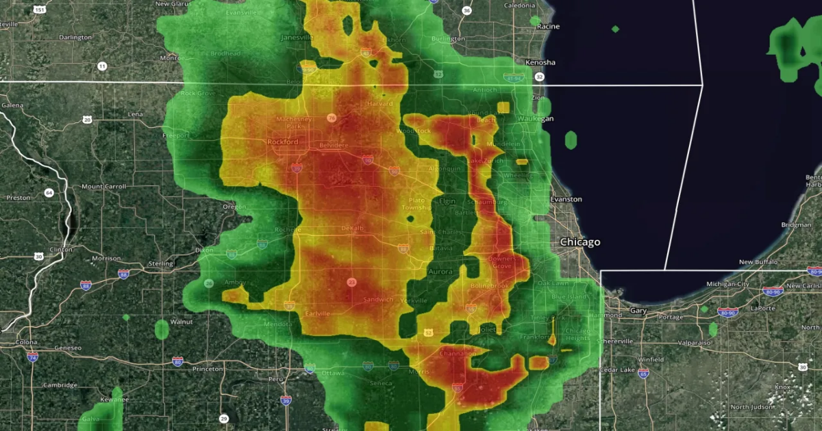
A Tornado Watch remains in effect for Ford, Iroquois, Kankakee, Livingston and Will counties in Illinois and Benton and Newton counties in Northwest Indiana until 9 p.m.

A strong low-pressure system is moving through from west to east, bringing with it high winds, the possibility of strong-to-severe thunderstorms — with hail and a chance of weak, pop-up tornadoes — and then wet, heavy snow later as temps drop.
Here’s a timeline for what to expect Wednesday into Thursday morning:

- Wednesday evening: Best chance for storm activity appears to be between 3 and 8 p.m.
- Wednesday night/Thursday morning: High winds and wet snow, heavy snowfall at times in some locations.


The severe threat for Chicagoland on Wednesday evening has actually increased as of Wednesday morning, now up to a Level 3 for parts of Will and Kankakee counties to the south and west and a Level 2 for the rest of Chicagoland. The main severe threat will be from 3 to 8 p.m. Wednesday.


Then, cold and snow move in on the back end of the system, with anywhere from a half-inch to 3 inches of wet, heavy snowfall predicted to come down by the Thursday morning commute.

The low-pressure system moving through Chicagoland will also bring very high winds, gusting up to 40 or 45 miles per hour, so the entire area will be under a Wind Advisory as the system passes through.
As for temps on Wednesday, there was very big difference between northern and southern locations in the early-morning hours, with temperatures reaching the upper 30s in Waukegan and McHenry, while areas like Kankakee, Morris and Peru were in the mid-50s.

The warm air should gradually move north as the day goes along and before the storm system moves through later. High temps Wednesday will reach the upper 50s, and into the 60s for southern areas.
Then, after the system moves through, temps will top out only in the low 40s on Thursday.


Chicagoland looks to go into a cooling trend following a warm start to the week.
After the cold front moves through Wednesday night, the first day of spring on Thursday looks to be cold and windy. Temps will rebound back into the 50s on Friday, but the coming weekend looks chilly, with highs topping out only in the low to mid-40s.


As for the forecasted snow from Wednesday night into Thursday morning, surface temperatures are warm, which will prevent accumulations from occurring on most area roadways. But colder outdoor surfaces and grassy surfaces are likely to welcome the new season of Astronomical Spring, which begins at 4:03 a.m. Thursday, with a fresh coating of snow that promises to whiten the ground.

Elsewhere across the country, a significant winter storm could bring blizzard conditions to portions of the Midwest and Central Plains.

Blizzard conditions are expected in the hardest-hit areas, including northern Kansas, eastern Nebraska and northern Iowa.

Full forecast details and more at the WGN Weather Center blog