The National Weather Service is continuing to update its forecast for Friday night’s severe weather event in the Tri-State.
Here’s what meteorologists at the agency’s Paducah, Kentucky office are saying about the outlook.
What has changed about the forecast since yesterday?
The risk for tornadoes has increased, according to a briefing issued Friday morning by the National Weather Service.

When will severe weather be possible in Evansville and Henderson?
The best window for severe weather in the Evansville area is between 11 p.m. Friday and 5 a.m. Saturday, the National Weather Service said in a Friday morning briefing. A second round of severe weather is possible midday Saturday.
What kind of severe weather is possible?
The primary hazards will be widespread damaging winds and tornadoes, according to the weather service. Large hail is also possible. The potential exists for what the agency classifies as “significant severe weather,” including winds of 70-75 mph (hurricane-force winds) and tornadoes that rate as EF2 or higher on the Fujita scale.
How will this event unfold?
Forecasters say models indicate a broken line of severe thunderstorms will develop over central Missouri on Friday afternoon and evening and then track east into the Tri-State.
Significant wind shear will be in place over the Tri-State, which could cause the storms to become severe.

It will be quite windy in advance of the storms, with south winds of 40-50 mph in place ahead of the line of storms Friday afternoon and evening.
Storms will be moving fast when they approach the Tri-State, reaching speeds up to 70 mph at times.
After a brief break, more severe storms with heavy rain are possible Saturday afternoon over Western Kentucky and Southwestern Indiana.
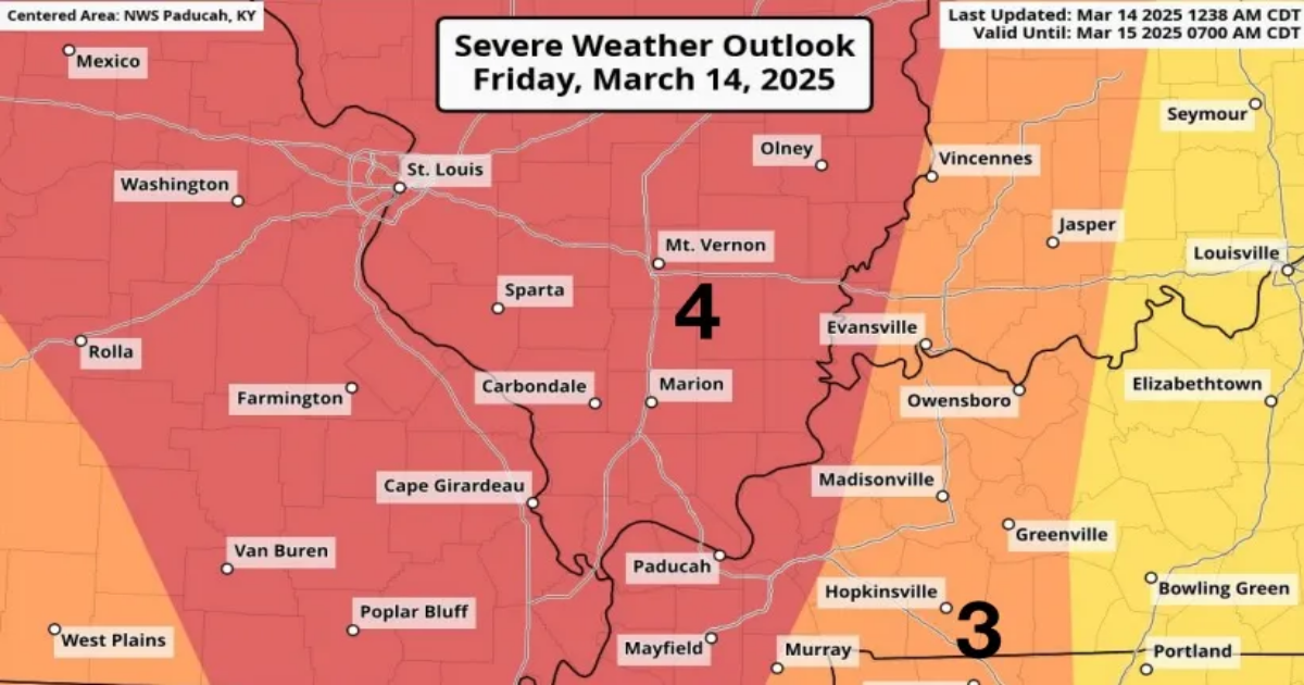
What is the risk level?
The Storm Prediction Center, a branch of the National Weather Service, has placed most of Southern Illinois and parts of far Western Kentucky in a “moderate risk” area for severe thunderstorms − the second-highest risk level the agency uses. There is a small area of Southwestern Indiana in the “moderate risk” area, as well, along the Wabash River in Posey and Gibson counties.

The Evansville area is in an “enhanced risk” area, which is a step below the moderate risk level.
How much rain is expected in Evansville and Henderson?
Between an inch and 1.5 inches of rain is expetced in the Evansville area through Saturday night. The heaviest rain will be over Western Kentucky on Saturday afternoon, where up to two inches is possible.
When was the last time a ‘moderate risk’ for severe weather was in place in the Tri-State?
The National Weather Service said the last moderate risk day was on May 26, 2024, which it deemed a “very high impact event.”
That storm system spawned tornadoes near Mortons Gap, Kentucky, and Fort Branch, Indiana.
Evansville weather radar