A rapidly strengthening storm system has Iowa in its sights Friday into this weekend.Here’s what’s ahead starting this afternoon.High winds return with high fire dangerAfter a few days of calm, gusty winds will return on Friday. Winds will increase during the morning hours with gusts of 20-30 mph by the lunch hour.Wind gusts of 35 to 50mph are possible during the afternoon hours. The strong south winds could cause some issues for high-profile vehicles on east-west roads and highways. Unsecured lawn furniture could be blown around as well.Although we have seen some significant rain and snow in the past week or two, warm and breezy conditions this week have allowed many fields to dry out. The stronger gusts will lead to high fire danger, especially for southern Iowa. Fires could spark and spread easily, so use caution with any equipment that can produce sparks outdoors.Severe storm risk increasingThis storm system will also bring Iowa’s first severe weather of the season.Thunderstorms are expected to develop over far southwest and southern Iowa around 3-4 p.m., and then race to the north and northeast through the late afternoon and evening hours.The storms should reach Des Moines and central Iowa between 4-6 p.m., then northern and eastern Iowa by 8 p.m.The main risk with any storms will be damaging winds with gusts of 60 to 80 mph possible. This could produce some minor roof and tree damage as well as scattered power outages. The tree damage should be somewhat limited by the lack of leaves on trees, but scattered issues are certainly possible.Some hail up to around 1 inch is possible, but this should be isolated. Most storms should only produce some small hail, if any at all.The good news is the air appears to be quite dry for this round of storms. That will greatly limit any tornado potential for most of the state. Again, the main risk with any storms that develop will be strong to damaging wind gusts. Colder air surges in Friday night with a few snowflakesAfter the storms roll through, colder air will blast in Friday night into Saturday, dropping temperatures into the 40s for Saturday afternoon.Some wrap around rain showers are possible as well, mainly through midday Saturday. With the colder air, some snow could mix in, especially over far northwest Iowa. At this time, significant snow is not expected, but it will certainly be a chillier day.The gusty winds will relax some by Saturday afternoon, but breezes to around 20 or 25mph will remain possible through Sunday morning. That will keep the colder air in place for both days, with highs in the 40s and lows falling into the 20s for Sunday morning.
DES MOINES, Iowa —A rapidly strengthening storm system has Iowa in its sights Friday into this weekend.
Here’s what’s ahead starting this afternoon.
High winds return with high fire danger
After a few days of calm, gusty winds will return on Friday. Winds will increase during the morning hours with gusts of 20-30 mph by the lunch hour.


Wind gusts of 35 to 50mph are possible during the afternoon hours. The strong south winds could cause some issues for high-profile vehicles on east-west roads and highways. Unsecured lawn furniture could be blown around as well.

Although we have seen some significant rain and snow in the past week or two, warm and breezy conditions this week have allowed many fields to dry out. The stronger gusts will lead to high fire danger, especially for southern Iowa. Fires could spark and spread easily, so use caution with any equipment that can produce sparks outdoors.
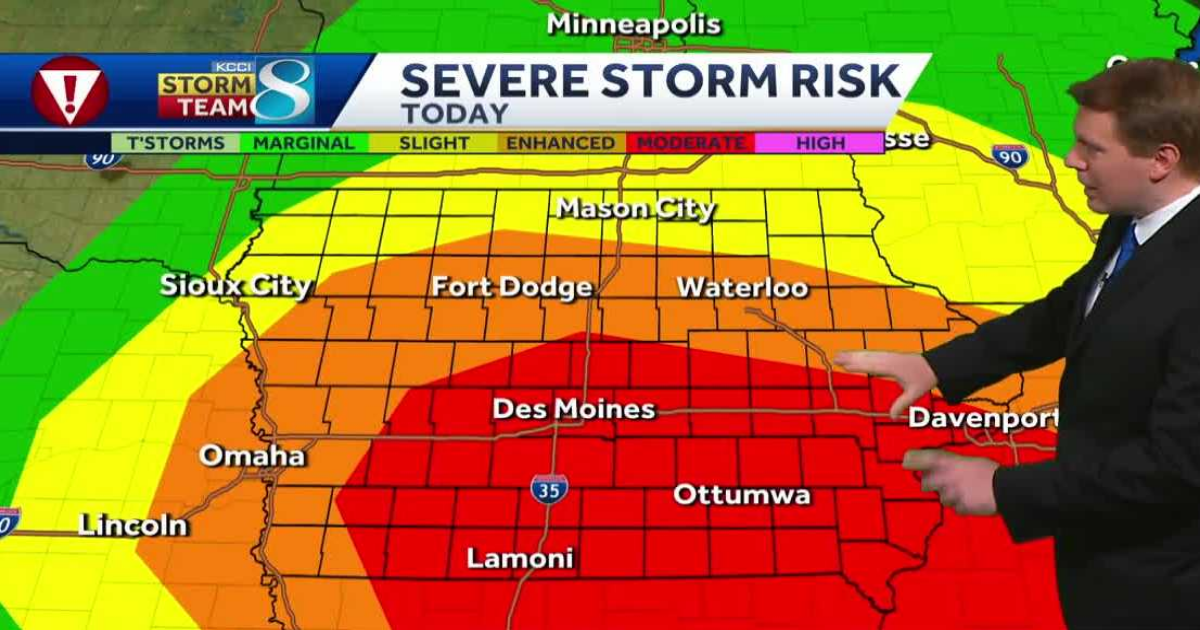
Severe storm risk increasing
This storm system will also bring Iowa’s first severe weather of the season.

Thunderstorms are expected to develop over far southwest and southern Iowa around 3-4 p.m., and then race to the north and northeast through the late afternoon and evening hours.

The storms should reach Des Moines and central Iowa between 4-6 p.m., then northern and eastern Iowa by 8 p.m.
The main risk with any storms will be damaging winds with gusts of 60 to 80 mph possible. This could produce some minor roof and tree damage as well as scattered power outages. The tree damage should be somewhat limited by the lack of leaves on trees, but scattered issues are certainly possible.
Some hail up to around 1 inch is possible, but this should be isolated. Most storms should only produce some small hail, if any at all.

The good news is the air appears to be quite dry for this round of storms. That will greatly limit any tornado potential for most of the state. Again, the main risk with any storms that develop will be strong to damaging wind gusts.

Colder air surges in Friday night with a few snowflakes
After the storms roll through, colder air will blast in Friday night into Saturday, dropping temperatures into the 40s for Saturday afternoon.

Some wrap around rain showers are possible as well, mainly through midday Saturday. With the colder air, some snow could mix in, especially over far northwest Iowa. At this time, significant snow is not expected, but it will certainly be a chillier day.
The gusty winds will relax some by Saturday afternoon, but breezes to around 20 or 25mph will remain possible through Sunday morning. That will keep the colder air in place for both days, with highs in the 40s and lows falling into the 20s for Sunday morning.