Millions of Americans should prepare for disrupted travel and winter conditions as a massive storm is set to bring ice, snow and freezing rain to much of the country, forecasters said Saturday.
The storm will first impact the Central Plains later Saturday and spread into the Ohio Valley on Sunday before reaching the Mid-Atlantic late Sunday and into Monday.
Northeastern Kansas into north-central Missouri could see over 15 inches. “For some, this could be the heaviest snowfall in over a decade,” the National Weather Service said.
Blizzard and whiteout conditions are expected in the central Plains, making driving conditions either dangerous or impossible without the risk of becoming stranded.
At least 8 inches of snow is expected in Indiana and central Kansas, while dangerous sleet or freezing rain is forecast between eastern Kansas and the Ozarks toward the Ohio Valley, according to forecasters. Meanwhile, the Central Appalachians will face freezing rain and ice, posing a risk of power outages and hazardous travel.
Winter storm warnings and winter weather advisories remain in effect from western Pennsylvania and West Virginia to far western Maryland, where snow totals of at least 6 inches are expected. Lake effect snow warnings are also set to continue from northeast Ohio, far northwest Pennsylvania, as well as parts of western and northwest New York State. Snow totals could reach 1 to 2 feet, according to the weather service.
“Over a dozen states are forecast to be impacted by one or more aspects of this storm,” AccuWeather Meteorologist Brandon Buckingham said.
Millions of Americans under winter weather alerts
A winter storm watch is put in place when weather conditions favor a winter storm that threatens life or property, according to the National Weather Service. A winter weather advisory is included when there is expected to be any one or more of the following: Snow 3 to 5 inches within 12 hours; sleet less than half an inch; freezing rain with sleet or snow; or blowing snow. A winter storm warning comes when heavy snow of at least 6 inches in 12 hours or 8 inches of 24 hours, or sleet over half an inch is expected.
Here’s how many Americans are under winter storm alerts Saturday afternoon:
Winter storm warning: Over 32,458,000 people, including a stretch from Kansas to Virginia.
Winter weather advisory: Over 14,616,000 people across parts of Montana, the Dakotas, Nebraska, Kansas, Colorado and more.
Winter storm watch: Over 11,744,000 people, mostly in Mid-Atlantic states including Maryland and Delaware.
Travel could be difficult or impossible
Forecasters urged drivers to check their weather forecasts and prepare for potentially dangerous or impossible conditions over the weekend.
From the Central Plains region into the Ohio Valley, severe travel delays are likely, the weather service said. Blizzard conditions are likely in the Central Plains, with wind gusts over 35 mph and heavy snow.
“Whiteout conditions will make travel extremely hazardous, with impassable roads and a high risk of motorists becoming stranded,” the weather service said.
From eastern Kansas to the Ozarks and Ohio Valley, travel will also be dangerous with likely fallen trees and power outages, the weather service said. Over one-quarter inch of ice is expected to accumulate.
After the snow comes the bitter cold
Lingering cold air after this winter storm could keep ice and snow on the ground for several days, AccuWeather said.
Colder than average temperatures will impact much of the country next week, from the Rockies eastward, according to the weather service. Temperatures will be 10 to 20 degrees lower than normal for this time of year from the Central Plains and Mid-Mississippi and Ohio Valleys through the Appalachians next week, forecasters said.
“Brutally cold temperatures will extend through the upcoming week,” the weather service in St. Louis, Missouri, said.
Power outages could make the situation more dangerous as it dips into single digits overnight in the region, the weather service there said.
National snowfall tracker
The map below shows the probability that an area could receive more than 4 inches of snow. Use the slider at the top left to toggle by day.
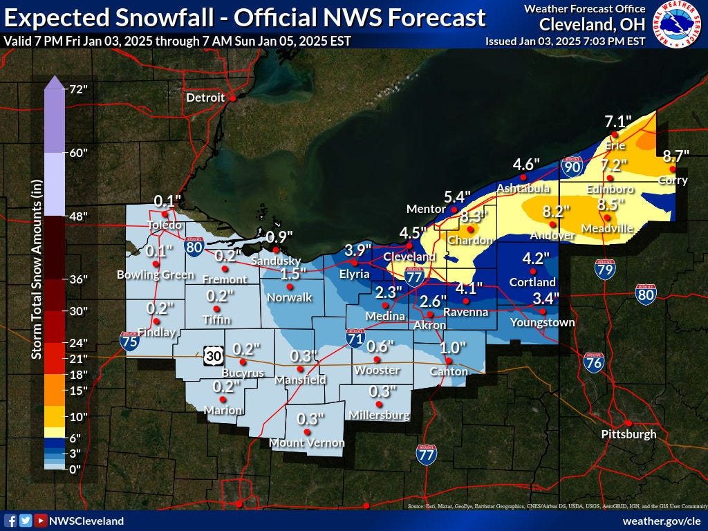
Cleveland expected snowfall
Snow is forecast for parts of the Cleveland area between Friday Jan. 3 through Sunday Jan. 5, according the National Weather Service.
Pittsburgh expected snowfall
Snow is forecast for parts of the Pittsburgh area between Friday Jan. 3 through Saturday Jan. 4, according the National Weather Service.
Indianapolis expected snowfall
Snow is forecast for parts of the Indianapolis area between Sunday Jan. 5 through Monday, Jan. 6, according the National Weather Service.
St. Louis expected snowfall
Snow is forecast for parts of the St. Louis, Missouri area between Saturday Jan. 4 through early Monday, Jan. 6, according the National Weather Service.
National weather map
National weather radar
This article originally appeared on USA TODAY: Major winter storm to hit this weekend. See forecast, snowfall maps


