MYRTLE BEACH, SC (WMBF) – Our team coverage continues this morning, where we’re giving you the First Alert to thick smoke across Carolina Forest and Horry County. This will cause travel issues as crews continue to battle the wildfire and hot spots through the week. We’re also keeping a close eye on some much-needed rain and the potential for a few strong storms Wednesday ahead of the cold front.
SMOKE & MORNING COMMUTE
Take your time this morning, especially if your morning commute takes you near the Carolina Forest community. Slow downs are anticipated and the visibility will be reduced to nearly nothing this morning as a temperature inversion and calm winds keep the smoke trapped at the surface.
Temperatures are chilly this morning with the upper 20s and lower 30s as you step out the door.

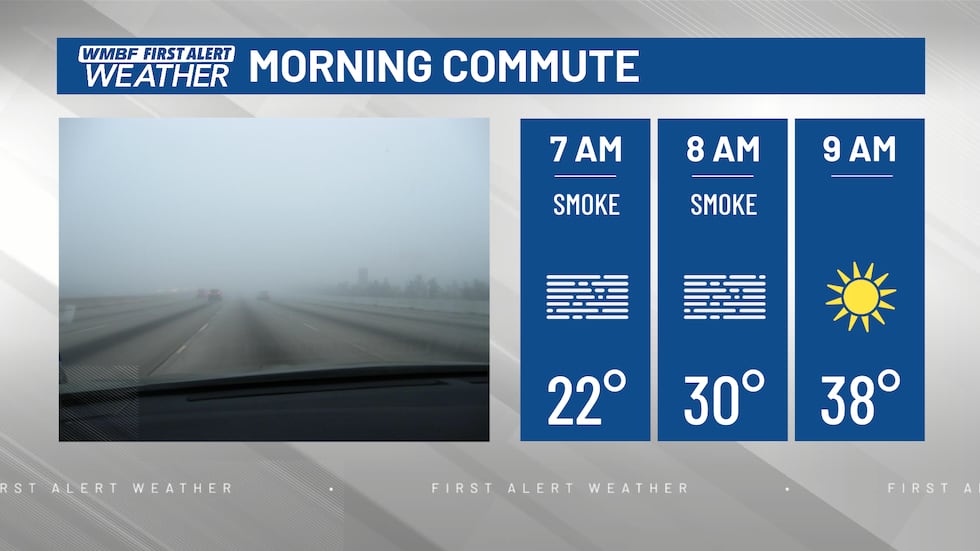
The THICK smoke will continue to settle near the surface this morning, causing a huge problem on the roads for those near Carolina Forest. TAKE YOUR TIME.(WMBF)
As we go throughout the day, a calm wind should begin to become more northeast this morning. This will once again push fog further southwest across 501, Forestbrook, Socastee, Market Common and other areas southwest of Carolina Forest.
Smoke and air quality issues are expected to be a problem for the next several days. Don’t plan to be out for long periods, especially in Carolina Forest. Sensitive groups or those with respiratory issues can wear a face covering or N95 mask to help with the smoke when having to be out today.
THIS WEEK

Expect plenty of sunshine once we see the smoke begin to move out of the area. Temperatures throughout the day will climb into the low-mid 50s along the beaches this afternoon. As you move inland, we’ll reach the upper 50s to near 60.
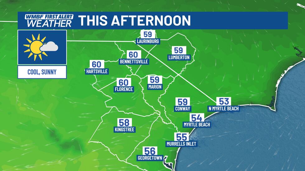
It’s a seasonable day, but a cool start will make it feel cooler.(WMBF)
Winds will begin to shift out of the southeast later tonight, pushing smoke to areas north and northwest of Carolina Forest tonight and into Tuesday morning.
Winds should remain breezy on Tuesday with gusts of 15-20 mph possible throughout the day. A southeast wind on Tuesday will blow smoke northeast throughout the day, but will also keep the potential for some wildfire trouble as crews continue to control the hot spots. Thankfully, humidity values will slowly start to creep up as highs reach the middle 60s for the Grand Strand. Inland areas will climb into the upper 60s to near 70. One thing you’ll notice for Tuesday is the clouds increasing ahead of our next system. We’ll start off the day with plenty of sunshine and end the day with mostly cloudy skies.

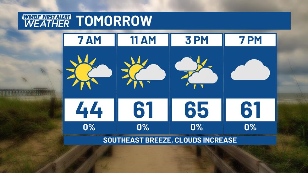
Winds shift, allowing for warmer weather. Clouds increase ahead of Wednesday’s system.(WMBF)
SEVERE THREAT WEDNESDAY
We’re watching Wednesday closely as the potential for severe weather remains on the table as a strong cold front moves through the area.
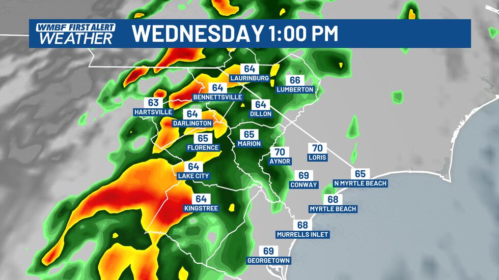
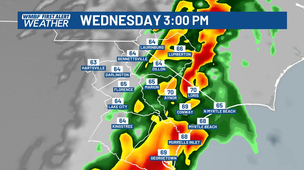
Here’s a look at what radar could look like by the early afternoon. The intensity of the line of showers and storms will need to be watched as this line pushes through the area. Damaging winds are the main threat at this time.(WMBF)
This looks to be a classic plenty of wind energy, low storm fuel type setup for the Carolinas, which usually results in a few strong to severe storms, but not widespread severe weather. While everyone will pick up on much-needed rainfall, not every storm or shower will prompt a warning.
A line of showers and storms will push through the area with strong winds. There’s plenty of wind energy to support a few strong to severe storms.(WMBF)
At this point, the line of storms looks to approach our area during the early afternoon and push through by the early evening hours.
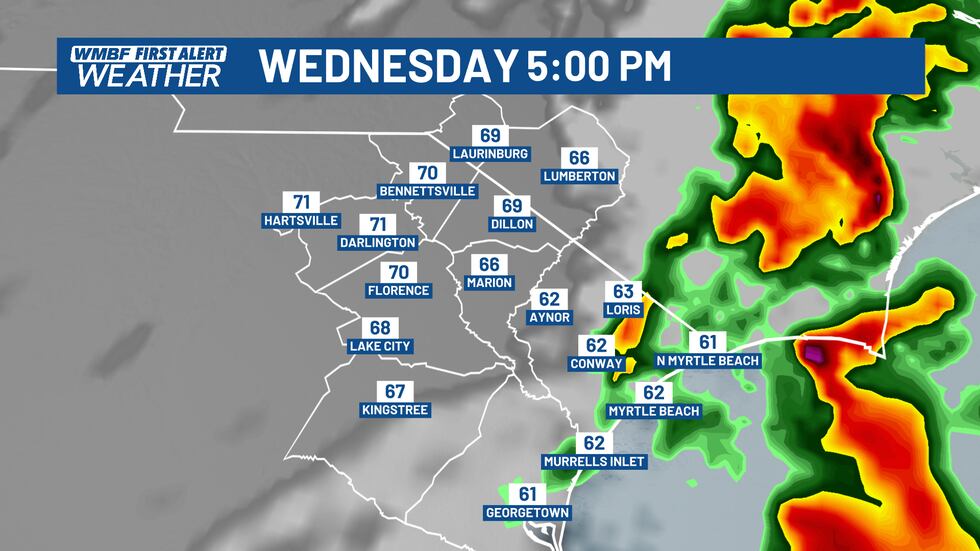
The new data this morning shows the worst of the storms out of the area by the early evening hours on Wednesday. Keep in mind, this is just ONE model run.(WMBF)
Strong gusty winds look to be the main threat here with locally heavy rain along the main line. Any strong storm that is embedded within this line of showers will have the potential to bring a few damaging wind gusts down to the surface. Once again, it’s too early to tell where exactly the best chance of that will end up, but we are under a LEVEL 2 severe weather risk for that potential.

We’re under a LEVEL 2 risk for severe storms Wednesday.(WMBF)
Highs on Wednesday will climb into the upper 60s and lower 70s throughout the day. Even outside of the storms, winds will gusts up to 25-30 mph. We’ll keep you updated on the latest with our severe weather threat as we start to gather more high resolution model data later this evening and into Tuesday.
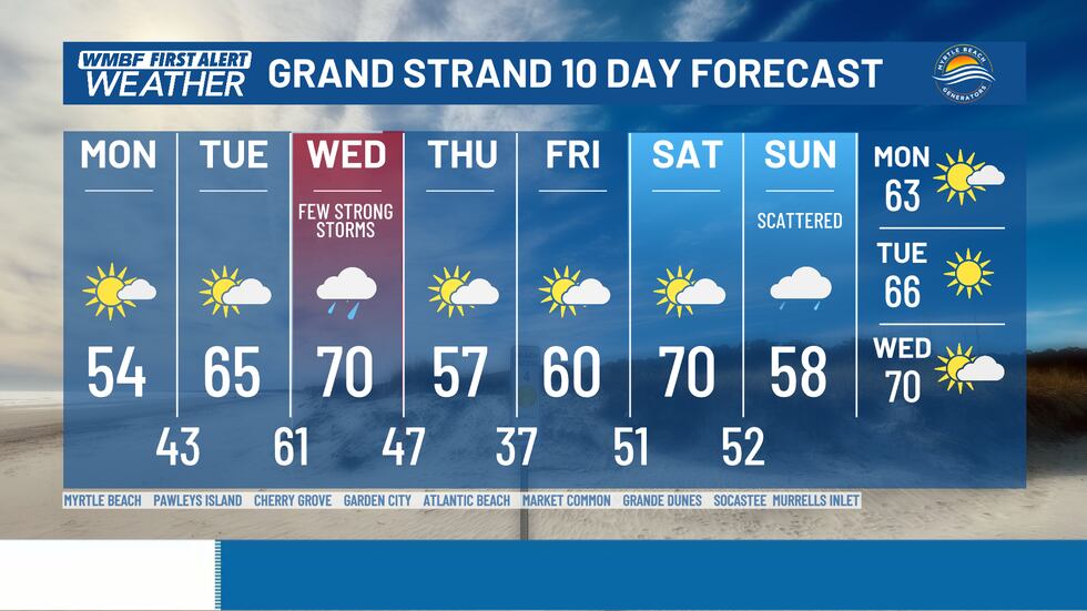
We’re highlighting Wednesday red for the potential of a few strong storms. We’re sunny on Thursday, Friday and Saturday before another system moves in on Sunday.(WMBF)
Copyright 2025 WMBF. All rights reserved.