Tropical Cyclone Alfred is approaching Australia’s east coast and could hit land in about a day. Ahead of the expected impact on one of the continent’s most populated and well-known stretches of shoreline, authorities have warned residents to make final preparations and be ready to shelter in place.
Alfred is forecast to make landfall near Brisbane, the capital of Queensland and Australia’s third-largest city. It will be the first tropical cyclone to hit southeast Queensland since a storm named Zoe touched down in 1974.
Landfall is expected late Friday or early Saturday, with sustained winds forecast to be around 45 to 50 mph with higher gusts, while its slow movement could deliver major to potentially historic flooding.
Schools and businesses across the area had already closed by Thursday. Travel is likely to come to a halt, as well — the international airport at Gold Coast is closed until further notice, as are regional bus lines.

With the storm’s slow movement, forecast models show rainfall totals up to 2 feet. If that happens, isolated higher tallies of up to 3 feet could also become a risk as some storminess lingers through the weekend.
Alfred had sustained winds of 60 mph and gusts to 75 mph late Thursday, Australia time, according to the Joint Typhoon Warning Center (JTWC). The storm is expected to slowly weaken as it moves westward toward the Gold Coast on Friday.
Australia’s Bureau of Meteorology (BoM) is forecasting Alfred will come ashore as a Level 1 of 5 storm on its scale, with winds roughly equivalent to a moderate tropical storm in the Atlantic Ocean.
“We’re expecting damaging to destructive winds, heavy to intense rainfall that may lead to life-threatening flooding and also dangerous storm tides” a meteorologist with BoM said in a recent video briefing.

Similarly, the JTWC forecast that Alfred would be just offshore as a 45 mph (40 knot) storm system late Friday night.
With landfall forecast for near or north of the city before drifting south while inland, the highest threats could focus near Brisbane itself. More generally, a heightened risk area runs along the Gold Coast from Grafton to the south of Brisbane to around the Sunshine Coast and Gympie in the north.
The region is home to about 4 million people, with most in the relatively dense Brisbane to Gold Coast city stretch that runs about 50 miles from north to south.
Rain from Alfred has arrived in waves associated with the outer bands of the storm — as much as 4 to 8 inches has fallen in some locations, according to the BoM. Intense rain and winds will pick up further by Friday morning across southeast Queensland and northeast New South Wales.

“We may see six-hourly rainfall totals between 200 and 250 mm [8 to 10 inches],” said the BoM in its briefing. “And 24-hour rainfall totals between 350 and 450 mm [14 to 18 inches].”
Heavy rainfall will stick around near the landfall region for about 48 hours after Alfred first moves inland, the storm weakening while slowly tracing the outline of high pressure to its southeast.
The Brisbane area seems like a potential focus of the most prolific rainfall, but that will be determined in the days ahead.
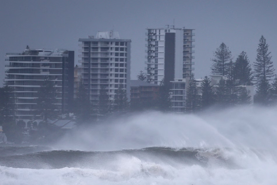
Once the equivalent of a Category 2 hurricane, large waves around 27 feet high near the storm center late Thursday will be comparatively subdued nearer shore — mainly in a 20-foot range, which is still capable of coastal damage. Battering waves will probably be at their most significant from around Brisbane southward to the northern beaches of New South Wales.
In addition to the waves, a general rise in sea level, known as storm surge, potentially 5-plus feet high, will further increase the coastal hazards, including river flooding.
Erosion has hit the Gold Coast region in recent weeks given a stormy pattern, so beach impacts could be major.
Alfred is the latest in a spurt of activity in and around the south-central Pacific Ocean in recent weeks. Last week there was a string of cyclones spinning offshore of Australia.
Such heightened storminess is fairly typical of a La Niña summer in the region, although this year has resulted in several higher impact events to the continent. As with other events globally in a warming climate, persistent above-average water temperatures in Oceania probably play a role.
The added moisture boost from the warm ocean also probably enhances precipitation potential. Forecast rainfall totals around 24 inches to as high as 36 inches in the hardest-hit zones would lead to daily and perhaps monthly precipitation records in the area.
Alfred should fully dissipate and its main effects on the region wane by early next week. However, the same general pattern that has delivered the slew of recent weather worries may persist.
Ben Noll contributed to this report.