A powerful winter storm will impact much of southern Minnesota and northern Iowa on Wednesday, bringing heavy snow and strong wind gusts of 40 to 50 mph. These conditions will create blizzard conditions throughout much of the day, especially while heavy snow is falling.
Latest Updates:
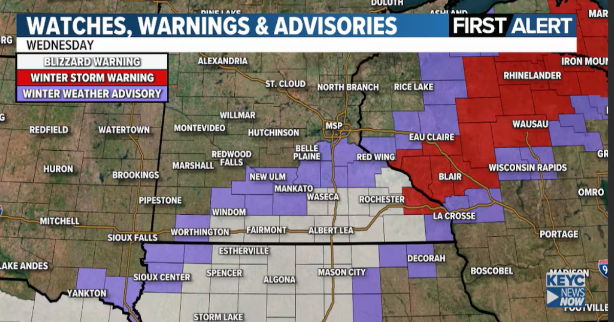
New data is suggesting that the low will track slightly further south which will pull the heaviest snow totals south. The NWS has downgraded the far northwestern edge from a Blizzard Warning to a Winter Weather Advisory. This includes the Mankato/North Mankato area. A Blizzard Warning remains in effect across southern Minnesota and northern Iowa where the heaviest snow and strongest wind will be.
Blizzard Warning: A Blizzard Warning is in effect for south-central and southern Minnesota and includes Waseca, Blue Earth, Fairmont, Jackson, Algona, Estherville, where the heaviest snow and strongest wind gusts are expected. Blizzard Warning is in effect from 5am through 7pm Wednesday. The timing could change depending on how long the system lingers.

Heavy Snow: The most significant snowfall will occur in a narrow band stretching from northern Iowa through south-central Minnesota into western Wisconsin. A sharp cutoff is expected northwest of Mankato, meaning areas just outside the core of the storm could see dramatically lower totals.
Mankato/North Mankato and area: 3 to 6 inches. This could be a situation where North Mankato 1-3+ inches and the far southeastern side of Mankato gets 5-6+. There will be a very sharp cutoff northwest of the band of heaviest snow.
Strong Wind: Wind gusts 35-45 mph, possibly up to 50 mph along I-90, will lead to blizzard conditions at times. The snow will be wet and heavy, making travel extremely difficult.
What Could Change:

This storm’s heavy snow band is extremely narrow, meaning a shift of just 10 to 15 miles north or south could drastically alter snowfall totals. A location could see 8 inches of snow or almost nothing, depending on the storm’s track. We will continue to refine the forecast as new data comes in.
Timing:
- Snow and wind begin before daybreak Wednesday.
- Snow continues through the day.
- Conditions improve from west to east by late Wednesday afternoon into the evening.
- Minor shifts in the storm’s track could impact these totals substantially. Stay tuned for updates throughout the day.
Travel Impacts:
Expect very difficult, if not impossible, travel conditions along I-90 and throughout southern Minnesota and northern Iowa on Wednesday due to heavy snow and strong wind.

Stay tuned and check your KEYC First Alert weather app for your specific details. The weather team will be watching this system closely and will continue to update as new information arrives.
Watches, Warnings and Advisories
 This image updates in real time as information changes.

Snowfall probability forecast updated 4pm on 3/18/2025(KEYC Weather)

Snowfall probability forecast updated 4pm on 3/18/2025(KEYC Weather)

Snowfall probability forecast updated 4pm on 3/18/2025(KEYC Weather)
KEYC First Alert 10 Day Forecast

Planner Forecast
 KEYC First Alert Planner Forecast: This image updates in real time as the forecast changes.
Click here to download the KEYC News Now app or our KEYC First Alert weather app.
Copyright 2025 KEYC. All rights reserved.