CEDAR RAPIDS, Iowa (KCRG) – After a nice Thursday, the weather turns active for the end of the week.

Satellite and Radar. (KCRG)
Your First Alert: Strong Wind Gusts
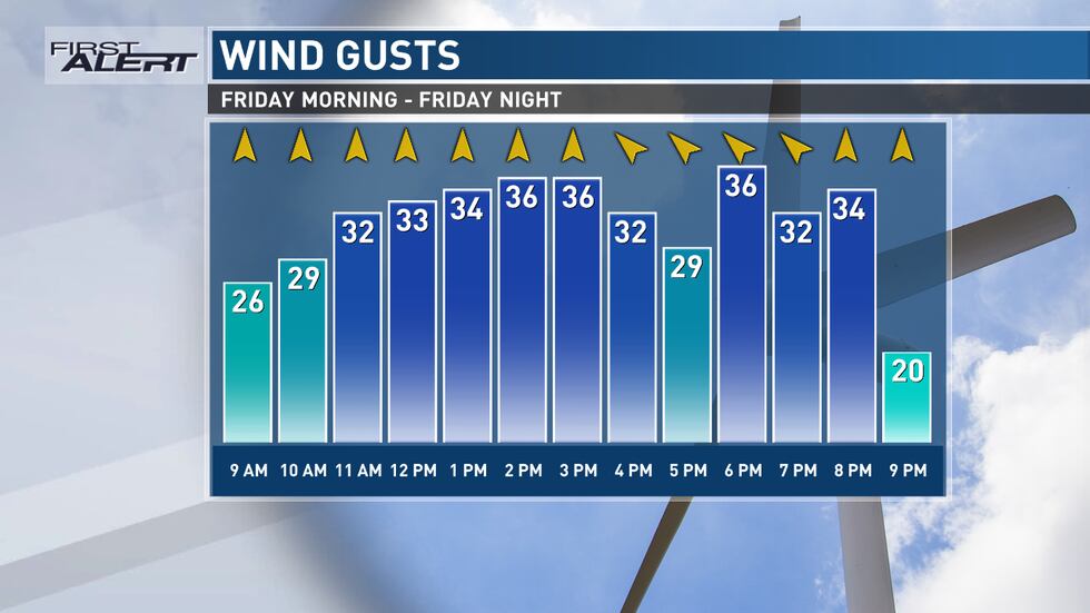
Friday Wind Forecast(KCRG)
Starting on Friday, a Wind Advisory will be in effect due to strong southerly winds, which will lead to elevated fire danger. These conditions are expected to persist throughout the day, with wind gusts reaching greater than 40 mph. The unseasonably warm temperatures will likely break record highs, with Friday’s temperatures surging well into the 70s.

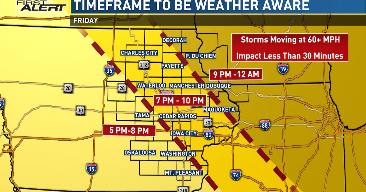
Your First Alert: Friday Severe Threat

Severe Weather Alerts (KCRG)
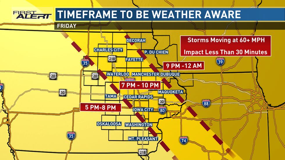
Storm Timing(KCRG)
Late Friday afternoon and especially Friday evening, the weather will take a dramatic turn as severe thunderstorms are expected to develop. The Storm Prediction Center has issued an Enhanced to Moderate Risk for the area, indicating a high likelihood of severe weather. The primary threats from these storms include damaging winds up to 80 mph and a few tornadoes.
Your First Alert: Blustery Weekend
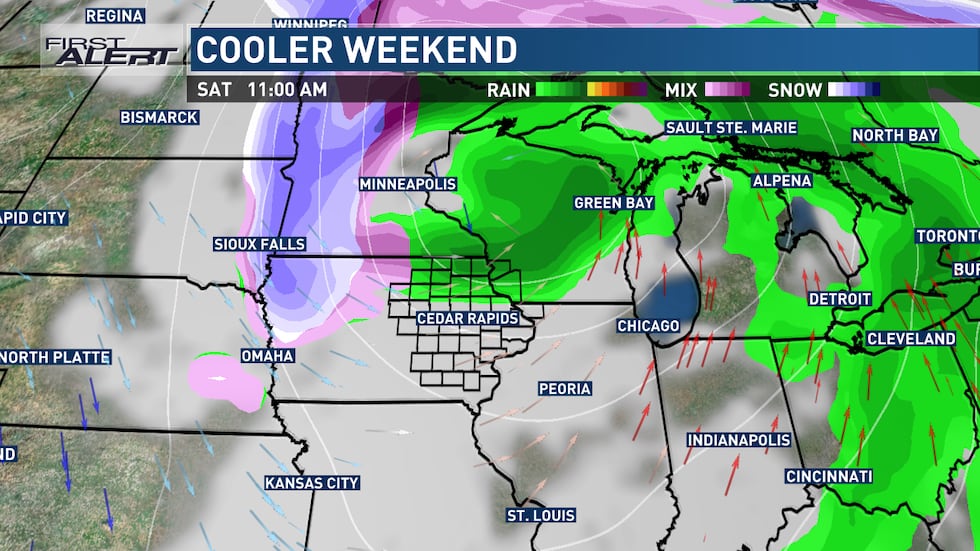
We’ll still feel the influence of this storm system over the weekend.(KCRG)

As the storm system moves through the region, strong winds will continue into Saturday, bringing cooler air and light rain or snow chances. The best chances for snow will be over northern Iowa, while other areas may experience gusty winds and scattered showers. The temperatures will steadily cool on Saturday, with highs dropping significantly compared to the previous days.
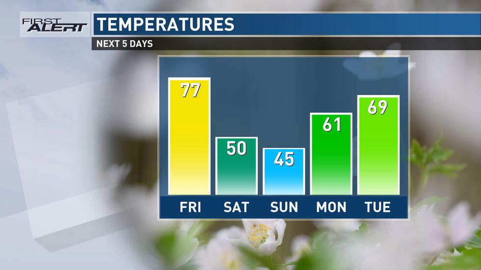
5 Day High Temps(KCRG)
By Sunday, the weather will become blustery and colder, with temperatures dropping 30+ degrees from the highs experienced on Friday. Despite the chilly conditions, a warmup is expected for Monday and Tuesday.
What to do if storms threaten your area
With this being the first risk for severe storms this season, it’s a good idea to review the steps to take if a warning is issued. Since storms will be moving quickly, your time to react may be shorter than normal.

If a storm approaches your area, seek shelter indoors. If a warning is issued, get to the lowest floor of your home, away from windows. In the event of a tornado warning, put as many walls between you and the outside as possible, like in an interior closet or bathroom. A basement is best if you have one. Cover your head and neck with pillows or blankets or a bike helmet if you have one. If you’re in a mobile home, abandon it for more substantial shelter. If caught outdoors, try to get to an indoor shelter. As a last resort, lie flat in a ditch while protecting your head and neck. Don’t seek shelter under bridges or overpasses.
It’s important to make sure to have multiple ways to receive warnings. A NOAA Weather Radio is a great tool in this case. Make sure it’s plugged in and turned on, ready to receive warnings, before you head to bed. We also recommend the KCRG-TV9 First Alert Weather App, which can give you customized alerts for your location. Of course, we’ll also provide updates on KCRG.com and KCRG-TV9 as conditions warrant.
Copyright 2025 KCRG. All rights reserved.