After days of light rain, a major storm walloped parts of Southern California on Thursday, bringing fears of mudslides in burn areas, heavy mountain snow, strong winds and a tornado that snapped trees and damaged homes.
Bands of heavy precipitation moved through Los Angeles County, prompting reports of some shallow debris flows in burn areas and scattered hail. Intense bursts of rain caused minor street flooding and several closures from southern Santa Barbara County down into Orange County. The Los Angeles Fire Department worked early Thursday to rescue someone stuck on a concrete alcove along the rising Los Angeles River in Boyle Heights.
Residents in a Pico Rivera neighborhood were jolted awake when a tornado with wind speeds reaching 85 mph formed around 3:15 a.m. and traveled roughly a mile, uprooting trees and tossing around outdoor furniture. No injuries were reported.
“I heard like a big old bomb. It’s my first tornado,” Edgar Reynoso said as he assessed a collapsed wall in his backyard. “It’s my first time living through it and … it was pretty scary.”

 A downed tree sits on a car along Glencannon Drive in Pico Rivera.
In the mountains around Los Angeles, San Bernardino and Riverside counties, several inches of snow had piled up by Thursday morning, triggering school closures in the area. The San Bernardino Fire Department said it had reports of several power outages.
A winter storm warning of heavy snow and winds gusting as high as 50 mph remains in effect through early Saturday, as another less potent storm takes aim at the region on Friday. An additional 6 inches of snow is expected across the Los Angeles, Ventura and Santa Barbara county mountains, according to the weather service.
The major ski resorts reported up to 10 inches of fresh powder and snowflakes still falling on Thursday morning. Mountain High received between 10 and 13 inches of snow, while Mt. Wilson received 4 inches. Gorman, a town in the Grapevine, received an inch of snow, said Ryan Kittell, a meteorologist with the National Weather Service in Oxnard.

Big Bear Mountain Resort reported more than a foot of snow at its three ski resorts, topping out at 18 inches at Snow Valley.
“It’s safe to say this storm was the biggest snowmaker,” Kittell said of the systems to hit Southern California this winter.
Rain was still falling around midmorning in Pico Rivera as residents milled around outside in disbelief after the twister charged through. Debris was scattered along Glencannon Drive and crews were working to remove several large trees that had fallen onto cars.
The tornado, which didn’t last long, measured as the lowest level on the Enhanced Fujita Scale, a rating used by meteorologists based on estimated wind speeds and related damage. The twister was on the upper end of the lowest rating, said Ariel Cohen, a meteorologist with the National Weather Service in Oxnard.

“While brief, it was still damaging,” Cohen said.
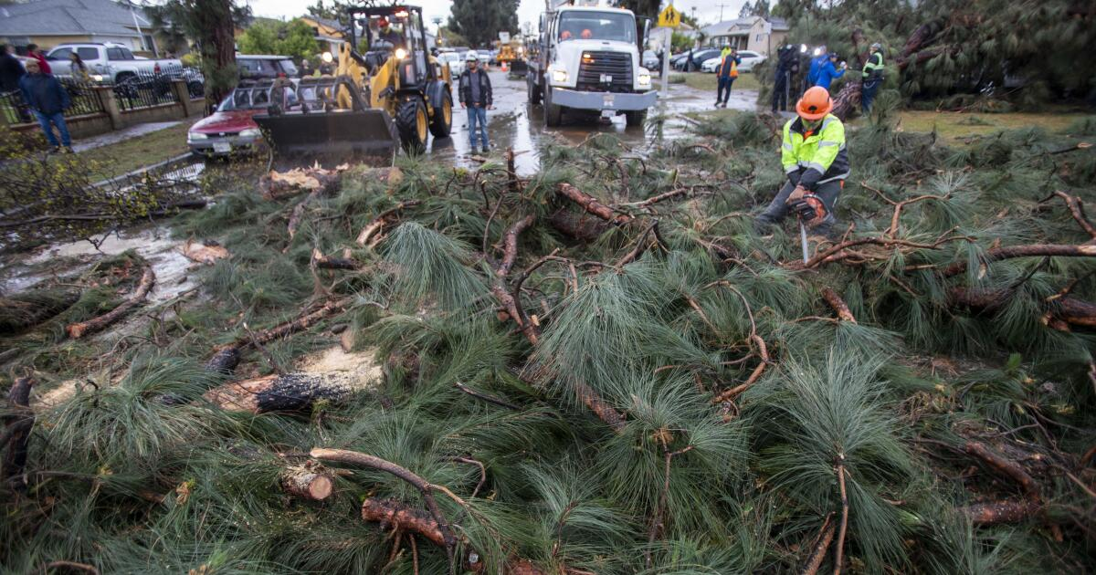
 Work crews remove downed trees and debris along Glencannon Drive in Pico Rivera.
Resident Cuba Garcia thought somebody was hitting the side of his home overnight, but when he looked at his security camera he realized that the strong gusts had flipped a metal canopy from his front yard onto his roof.
As the sun came up he was trying to figure out how he would get the structure down. After the rain stopped, he planned to climb onto the roof with some friends and try to break apart the structure, which sat on his home like an upside-down turtle.
“Earthquakes we can go through in our daily lives and be fine, but a tornado? Tornadoes are just something totally different,” Garcia said.
Though tornadoes aren’t common in Southern California, the weather phenomenon also isn’t unheard of in the region. During a similarly sized storm last month, a tornado tore through a mobile home park in Oxnard, ripping roofs off homes and tearing down power lines.
The last significant tornado in the area was in March 2023 in Montebello, damaging 17 structures and injuring one person.
Overnight, the wind was howling so loudly outside Carlos Aguilar’s Pico Rivera home that his dog woke him up. He heard a thump and when he looked out his window he saw that a 75-foot pine tree had fallen into his front yard, narrowly missing his front door.
His 2018 Hyundai Elantra wasn’t as lucky. The car remained under the tree several hours later.
“I’ve never seen anything like this,” Aguilar said.
The deluge of rain expected from the storm prompted concerns this week from officials and residents about the burn scars in Los Angeles County.
Communities near the Eaton, Palisades and Sunset fire burn zones in Los Angeles and neighborhoods in the Airport fire zone in Orange County were placed under evacuation orders and warnings ahead of the rain. Several schools in the Malibu area canceled classes Thursday due to road closures and safety concerns from the storm.
Mud and debris flowed onto a closed section of Pacific Coast Highway in West Los Angeles during the heaviest bands of rain, but crews were able to clear the material quickly, according to Caltrans.
Rain rates over the Eaton fire burn scar reached up to an inch an hour during the peak of the storm early Thursday. Experts say the risk of mud and debris sliding off burned hillsides increases when rain starts falling at a rate of half an inch per hour.
Despite the heavy bursts of rain, the area appeared to have avoided serious damage from debris flows, said Kittell, the meteorologist. Cameras in the region showed a torrent of water, mud and tree branches flowing from hillsides in the area into basins designed to catch such materials during heavy rain.
In the Santa Ana foothills near Rancho Santa Margarita in Orange County, officials closed Trabuco Canyon Road after rain swept rocks, tree limbs and several inches of mud across the roadway.
In San Juan Capistrano, a man had to be rescued by helicopter Thursday morning after his SUV got stuck in fast-moving water and mud in a creek along Trabuco Creek and Rosenbaum roads. The man, who was not injured, was hanging on to a tree when crews arrived, according to the Orange County Fire Authority.
It is not clear how the vehicle ended up in the creek. Fire officials warned the public to stay clear of moving water during wet weather. “It does not take a lot of water to move a person or a vehicle downriver,” the fire department wrote on X.
After a brief reprieve Thursday night, more light showers are expected to hit the region on Friday. But this week’s back-to-back storms have already delivered a significant dose of moisture to Southern California.
Beverly Hills has received 1.29 inches of rain so far this week. Downtown Los Angeles received 1.21 inches, Woodland Hills 2.27 inches and the Eagle Rock Reservoir 1.88 inches, according to the weather service.
Rain totals were even higher in the Los Angeles County mountains, with the Cogswell Dam receiving 3.74 inches and Crystal Lake seeing 3.07 inches over the three-day period.
In Orange County, Lower Silverado Canyon received 0.91 of an inch of rain in a six-hour period that ended at 5 a.m. Thursday. Coto De Caza received 0.75 of an inch and Corona del Mar 0.71 of an inch, according to the weather service.
The region is still playing catch-up after a drier-than-normal start to winter. Downtown L.A. has received 6.55 inches of rain since the water year began Oct. 1. That is below the average for this point in the water season, 11.88 inches. The annual average is 14.25 inches.
“Our deficits are huge,” said Alex Tardy, a meteorologist with the National Weather Service in San Diego. “We’re still behind 5 or 6 inches of rain all along the coast. We’re still under 50% of normal.”
In the Palisades burn scar, the Getty Villa area, the Highlands, the Bienveneda area near Temescal Canyon Park, Rivas Canyon/Will Rogers State Park, Mandeville Canyon above Tanners Road, Old Ranch Road and Rustic Creek are under evacuation warnings starting Wednesday morning.
Areas east and south of Runyon Canyon in the Sunset fire zone are also under an evacuation warning. In the Hurst fire area, an evacuation warning has been issued for Olive Lane in the Oakridge Mobile Home Park, according to the Los Angeles Fire Department.
The evacuations are expected to last until 6 p.m. Thursday, according to the Los Angeles Fire Department.
Malibu also issued evacuation warnings.
The areas include Carbon Canyon, Carbon Beach East, La Costa Beach/La Costa (hillside), Las Flores Creek, Las Flores Mesa, eastern Malibu, Big Rock, Las Tunas Beach, Topanga Beach Road, Carbon Beach Terrace, Carbon Beach, Rambla Pacifico, Carbon Beach West/Malibu Beach, Sweetwater Canyon, Sweetwater Mesa, Serra Retreat, Malibu Creek, Cross Creek, Malibu Colony, Civic Center, Malibu Knolls, Malibu Road, Malibu Country Estates, Puerco Canyon and Piuma Road.
In the Eaton fire burn scar, officials warned residents to prepare to leave their homes ahead of the storm.
The city of Sierra Madre issued mandatory evacuation orders for homes directly below the Sierra Madre and Lannan debris basins. Evacuation warnings have been issued for other hillside-adjacent neighborhoods in the community. Those evacuations will remain in effect through 6 p.m. Thursday, according to the city.
Evacuation warnings were also issued for homes near the San Gabriel foothills in Altadena.
Authorities visited properties in areas that are at especially high risk to issue specific evacuation orders ahead of the storm, according to the city of Los Angeles.